CLICK on the
ITALICIZED Working Links
Below
for Other Pages
(Under construction)
Life in Foster's
Meadow in the last half of
the 19th Century
The Wild, Wild East
The Foster's Meadow
Chronicles
Late 19th Century
Foster's Meadow Families
Rottkamp
Froehlich
Hoeffner
Herman
Krumenacker
Fausner
Hoffman
Hartman
Schmitt
March
Finn
Makofske
Zimmer
Why Foster's Meadow
is the Long Island
Community that Time forgot.
The Great Waters
To Be or Not To Be
New York City,
That is the Question.
|
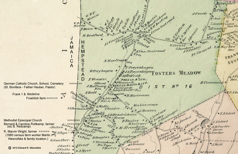
Foster's
Meadow
as a part of Long Island history is, in a seemingly contradictory
way, both one place and several geographical places on Long
Island.
While one might think of
Foster's Meadow as
one place because of the single name the fact is Foster's Meadow has existed
in
different ways and phases over historical time.
The First Foster's Meadow is
an area of somewhat open grassy plains in the Town of Hempstead and is
a colonial
and early Federal backwater for many years stemming from the earliest
settlement by the
Foster Brothers in the late 1600's and its use for open livestock
grazing.
The Second Foster's
Meadow emerges in
the early 1800's as a crossroads hamlet with a post office, general
store, school, toll house and inn on the Hempstead to Jamaica
Road, the major east-west wagon route of the time. Its
pattern of habitation paralleled
the crossroads hamlet patterns of Franklin Square, one and one-half
miles east, and Washington Square about two and one half miles east on
the same Hempstead to Jamaica Road. They too were developed
on intersections of the major travel path to Jamaica and the west
(Brooklyn and New York). Many of its inhabitants were
of English and Dutch descent. Common family names of the time
were Rhodes, Hendrickson, Van Sicklen (Van Siclen), Nostrand, Van
Nostrand, Watts, Remsen, Stringham, Higbie among others.
The north road crossing was
the Plainfield
Road emanating out of the place of modern day Floral Park. As
it
crossed Hempstead Turnpike (running east-west), as it is known today,
and extended southwestward, it was called the Foster's Meadow Road.
It followed
the path of a small creek (variously Simonson's Creek and Foster's
Meadow Creek) that flowed water south toward Jamaica Bay.
Today, Foster's Meadow Road is known as "Elmont Avenue".
As the road and the creek proceeded southwestward, they
passed from the Town of Hempstead into the Town of Jamaica.
This political subdivision involving government authority and
the application of law created political ambiguity in the life of
Foster's Meadow.
It was the Foster's Meadow
Road extending
southestward from the hamlet that served to create a Third
incarnation of Foster's
Meadow. Primarily German agriculturists began settling into
the
area by buying or renting farms around 1850. Their life and
social institutions created a second ethnically based community center
for Foster's Meadow focused around Dutch Broadway and Central Avenue,
roads that intersected Foster's Meadow Road in an east-west fashion.
There, German cultured and speaking institutions were
developed:
two German speaking churches, a parochial school,
and numerous hotels
that served as beer halls, social venues for
entertainments, meeting places for the locals and rest stops
for
travelers and market going farmers from farther east.
With
this development, Foster's Meadow entered its identity life phase as an
ambiguous
community. The ambiguity was to grow to the point of eventual
dissolution.
The nature of the
agriculture
entrepreneurialism and its spread post 1870 from the Foster's Meadow
Road westward into the Springfield Road area in the Town of Jamaica and
southward into the
outskirts of Valley Stream came to create in the public imagination a
sense that all farming in southern Queens County, particulary by German
farmers, was "Foster's Meadow farming". And so in this Fourth
incarnation, the ambiguity of Foster's Meadow as a geograhical
locale increased.
With ambiguity of place
creating
geographical orphans in the earlier generations of inhabitants of the
area, with a changing
economic tide at the turn of the 20th Century, with urbanization and
real estate economics under
new patterns, Foster's Meadow was eventually to disappear as a
real geographical home for anyone.
But beyond being a historical
geographical puzzle, Foster's
Meadow does have significant historical reality for Long Island.
It is the place
where the productive Long Island entrepreneurial
agriculture took off and generally moved further
east (with a sprinking moving north of New York City); where a
transformative
struggle between urban
powers and rural ways of life were fought out; where the adaptation
to transportation technology and corridors influenced the
subsequent patterns of Long Island habitation; and a place where long
lasting social ways and institutions derived primarliy from German
immigrants were sown into Long Island life.
For the purpose of reference, this
website considers Foster's Meadow to embrace the goings on from
Springfield Road on the west to Franklin Square on the East; from
Floral Park on the north to Rosedale (Tn. Jamaica) and Valley Stream (Tn. Hempstead) at the southern edge.
|